1980
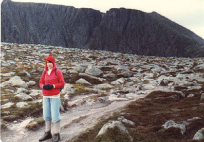
<< Anne wrapped up against the cold on the col between Cuidhe Crom and Meikle Pap, with the cliffs of Lochnagar behind,
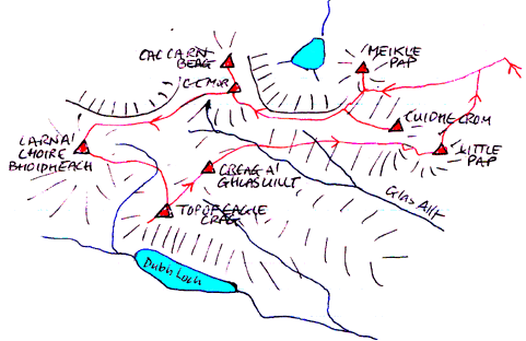
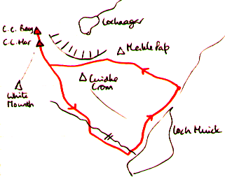
The route map from 1980. At that time, Cac Carn Mor and Cac Carn Beag were counted as separate tops. >>
Lochnagar, 1155m, and
Carn a'Choire Bhoidheach, 1110m.
1980 ascent ...... of Lochnagar on a cold Septmeber day ......
|
Date: 13/09/1980 |
Tops and Munros |
|
Companions: with Anne, and Mary and Conan Fischer |
|
|
Distance: 18km | |
|
Climbing: 750m | |
|
Time: | |
|
Weather: very cold | |
|
Munro Tally: M18, T27 | |
|
One of my early outings, along with Mary and Conan, from a base in a B&B in Braemar - the height of luxury for us in those days, when our mortgage payments were over half of our income! Anyway, I don't remember much, except that it was very cold at the top. To escape the biting wind, we decided to descend by the Glas Allt and back along Loch Muick. It was 24 years, almost exactly, before I returned to the mountain. See below for details. | |
|
|
1980 << Anne wrapped up against the cold on the col between Cuidhe Crom and Meikle Pap, with the cliffs of Lochnagar behind,
The route map from 1980. At that time, Cac Carn Mor and Cac Carn Beag were counted as separate tops. >> |
| |||
2004 round of (nearly) all the tops ....... on a warm August day ......
|
Date: 31/08/2004 |
Tops and Munros |
|
Companions: alone |
|
|
Distance: 25km | |
|
Climbing: 1000m | |
|
Time: 8 hours | |
|
Weather: good clear day, but cold northerly breeze around the summit cliffs | |
|
Munro Tally: M173, T289-294 | |
|
A fine late summer's day. I had to be in Aberdeen to deliver a course on 1st September. It had been a frustrating summer of poor weather, but the forecast for just this one day looked good. Not only that, but there was to be no stalking on Lochnagar, so I set off early from Selkirk, and arrived at the Loch Muick car park just before 11am. The car park was busy, but the hill turned out to be quite quiet. There was a cool breeze from the NW, but the skies were blue, and I set out confidently along the "tourist track" (fit for the Prince's Land Rover). Passed through the lovely pine woods behind Allt-na giubhsaich, and on up the hill. Sure enough, the Land Rovers were at the top of the track, collecting the result of the previous day's stalking, perhaps destined for Balmoral. Leaving the track at the highest point, I branched left on to the path leading toward the col below Meikle Pap (see 1980 photo above). This time my target was to do a round of both Munros and all the scattered tops (except for the northern outlier, Meall Coire na Saobhaidhe). So a short steep diversion to the right and I was on the rock tor summit of Meikle Pap - a superb viewpoint - at 12.40. A rest and a sandwich was called for, before the drop back to the col, and another steep ascent on to the Lochnagar plateau. Decision required - visit Cuidhe Crom now or later? Dropped my rucsac at a cairn on the plateau, and made the 10 minute diversion to the rocky top of Cuidhe Crom, armed with camera only. That was 2 tops added to the tally. It was cold standing around, so I set off again briskly along the wide and eroded path across the plateau, leading up to the massive cairn of Cac Carn Mor. Although the title would suggest that this was the top of the mountain, not so - it is not even counted as a top any more! Took a detour to the top of the cliffs, and peered down the huge gully splitting the cliffs between CC Mor and CC Beag. Reached the real top of the mountain, Cac Carn Beag - a small conical rocky tor - at 14.10. Again, admired the views in all directions, especially back across the coire to Meikle Pap (see below). After a rest, I set off across the plateau to the west, along an easy path, skirting round the NW coire towards the cliffs of The Stuic. The stalker's path continued towards Carn an t-Sagairt Beag, but I branched off to the left to reach the almost level top of Carn a' Choire Bhoidheach, the 2nd Munro of the day, often known as The White Mounth. Found a spot sheltered from the wind by some of the giant boulders scattered across this "summit". There cannot be many flatter topped Munros than this one. Another bite and drink while admiring the view, then back eastwards again. As soo as the path began to drop into Coire Bhoidheach (a wide shallow depression in the plateau), the wind dropped, and for the first time it felt warm - warm enough to swap trousers for shorts! Skirting round the coire, I soon reached the "Top of Eagle Crag", where I got very close to a group of deer before they noticed my approach, and bounded off effortlessly. From just beyond the 'top". I peered down into the Dubh Loch, and across towards Broad Cairn and Cairn Bannoch. The next top (Creag a' Ghlas Aillt) was reached by a 10 minute stroll across easy terrain. Next I headed across teh upper reaches of the Glas Allt, and contoured around the southern slopes of Cuidhe Crom. This became very bouldery, and proved to be the hardest part of the day - probably would have been easier to go back up to the summit of Cuidhe Crom. Eventually, the pleasing small summit of Little Pap (final top of the day) appeared below, and soon i was seated comfortably, enjoying the view and the reamins of my food at 17.00. I might have stayed there for hours, but it was time to move on. A short steep descent to the north, then sheep/deer tracks across the moor, led back to the main path. Back to the car - suitable tired - at 18.50. | |
|
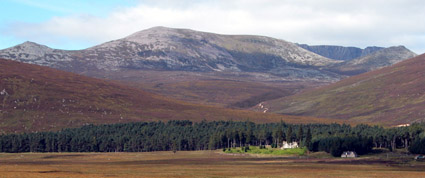
Lochnagar from Glen Muick From the road about 1 mile before the car park - a fine morning, with blue sky, and just a little high cloud. Little Pap on the left, Cuidhe Crom in the centre, the dark cliffs of Lochnagar to the right above the col separating Meikle Pap (extreme right) from the plateau. The land rover track can be seen climbing up behind Allt na giubhsaich. |
| ||||
|
|
| ||||
|
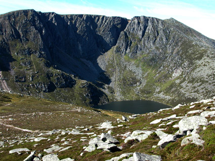
The coire of Lochnagar (above and above right) Views from the slopes of Meikle pap across the coire to the cliffs of Lochnagar. Stictly speaking, Lochnagar is the lochan in the coire; the correct name for the summit is Cac Carn Mor. And, to add to the confusion, the highest point is the small rocky tor seen to the right of the cliffs, called Cac Carn Beag. Don't ask what Cac Carn Mor means in Gaelic - its not very pretty! the slighly different view, above right, is looking more NW rather than W, and shows the Cairngorms in the distance, with the top I didn't climb over to the right, Meall Coire na Saobhaidhe. Next time ...
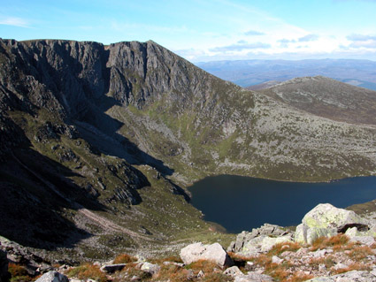
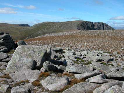
View from Cac Carn Beag (right) Looking east from the summit acroos the plateau above the cliffs - the lochan is hidden 400m below. Cuidhe Crom is the green top to the right, and Meikle pap to the left.
|
| ||||
|
|
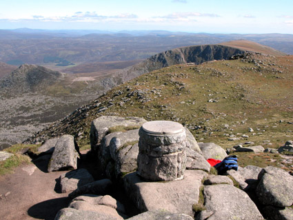
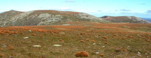
The plateau of Lochnagar left: from Cuidhe Crom, looking west - Cac Carn Beag to the right (small pyranid above right hand cliffs), Cac Carn Mor in centre (green dome), and the Stuic to the left. below:
from Carn a' Choir Bhoidheach (the White Mounth), looking
east - CC Beag on left, CC Mor in centre, Cuidhe Crom to the
right. | ||||
|
| ||||
|
|
<< route plan
To see a road map of the area around this mountain, click here If you want to see a 1:50000 OS map of the mountain, wait until the road map is displayed by streetmap.co.uk, then click the third "house" from the left on the zoom symbol, which will be displayed below the road map:
| |||
|
return to Mountains home page |
Comments or questions? david@dbethune.com |